Decoding the database:
A critical analysis of open source GIS tools for humanistic mapping
Alison Link | Academic Technologist, University of Minnesota - College of Liberal Arts
Mapping and Human Memory
"...for example, if we wish to recall a horse, a lion, or an eagle, we must place its image in a definite background."
- Rhetorica ad Herennium, 3.16 - 24; trans. Harry Caplan (Loeb, 1954)
"...the backgrounds are very much like wax tablets or papyrus, the images like letters, the arrangement and disposition of images like the script, and the delivery is like reading."
"And these backgrounds ought to be of moderate size and medium extent, for when excessively large they render the images vague, and when too small often seem incapable of receiving an arrangement of images."
"Often in fact when we declare that some one form resembles another, we fail to receive universal assent, because things seem different to different persons. The same is true with respect to images: one that is well-defined to us appears relatively inconspicuous to others. Everybody, therefore, should in equipping himself with images suit his own convenience."
Where to start?

Techno-Positionality
"It is a way of relating to technology that is neither entirely inside nor outside, relevant nor irrelevant, constructive nor destructive... The 'conflicted insider' techno-positionality is steeped in the technicalities of GIS, and yet seeks resistive practices, new collusions, and irreconcilables to challenge GIS at the level of code."
- Wilson, M. (2009). "Towards a Genealogy of Qualitative GIS", Qualitative GIS
The Process
- Conduct a literature review and interviews with individuals engaged in humanities work. Identify some of the current pain points in the humanities vis-à-vis existing GIS tools.
- Identify three points of critique that seem relatively tractable to explore with existing technical tools.
- For each critique, craft one or two examples illustrating ways to stretch existing technologies towards ends that may prove more useful/interesting to humanities scholars.
What this is not...
- A comprehensive critique of all humanistic shortcomings in GIS
- Technologically elegant, optimized computational solutions to humanities-related questions in GIS
What this is...

The Technologies
- PostgreSQL + PostGIS - for spatial data management
- QGIS - for spatial visualization
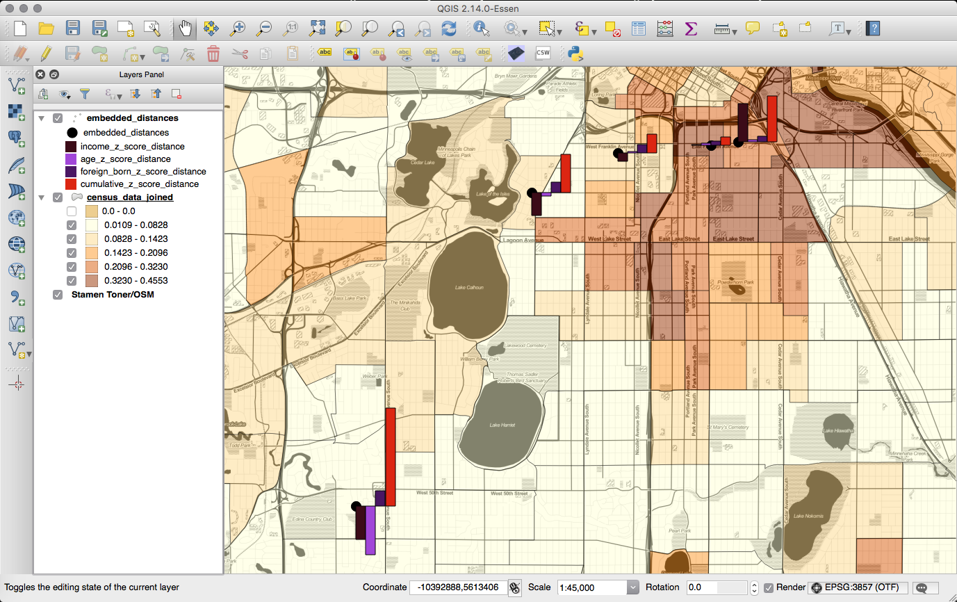
Critique #1: Humanities GIS needs more nuanced concepts of “distance” than GIS currently provides
"When you're in a new place, you're bombarded with all of those little nuances every single day. They add up to feeling like you are totally out of place. You look out of place. Your mannerisms, your clothes, your accent, you ability to pay the bus driver properly...all mark you as out of place to everyone else."
- E. Venditto (History)
"I am imagining in my head a Venn diagram, but it's a muddled space. It's strange [...] you can be somewhere, but you can't actually fully inhabit self in that place. It's a strange thing to try to tease out."
- M. Brito (Philosophy)
Example 1.1: Embedded distance calculation with U.S. Census data
CREATE OR REPLACE FUNCTION zScore(observed_val numeric,
	median numeric, margin_of_error numeric)
RETURNS numeric AS $$
	BEGIN
	RETURN (observed_val - median) / (margin_of_error / 1.645);
	END;
$$ LANGUAGE plpgsql;

CREATE OR REPLACE FUNCTION zScoreProportion(observed_val numeric,
	observed_cases_in_pop numeric, total_pop numeric)
RETURNS numeric AS $$
	DECLARE
		pop_proportion numeric := observed_cases_in_pop /
		total_pop;
	BEGIN
	RETURN (observed_val - (pop_proportion)) /
	sqrt(pop_proportion * (1 - pop_proportion));
	END;
$$ LANGUAGE plpgsql;
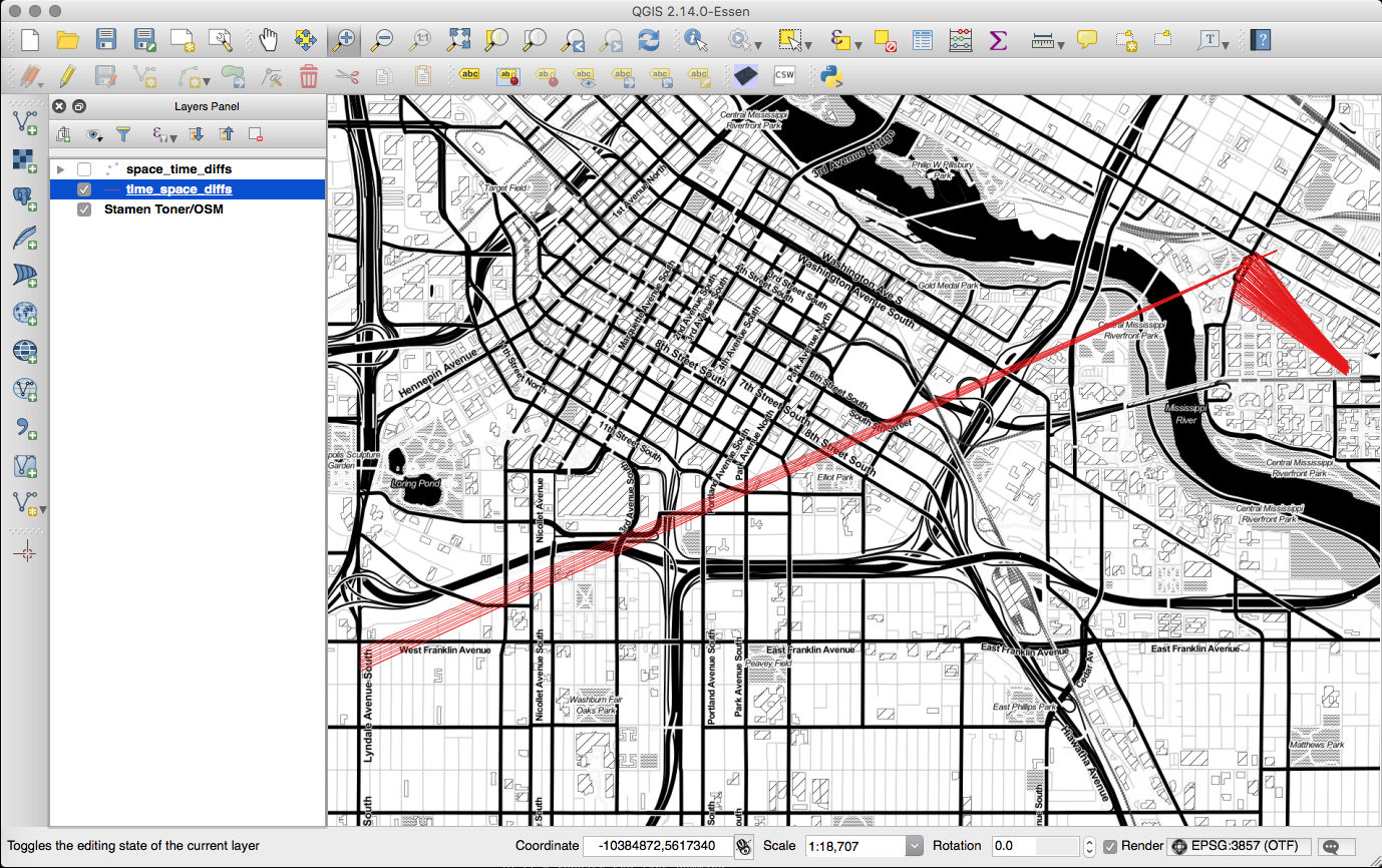
Critique #2: Humanities GIS needs a more robust approach to incorporating time into spatial analyses
"When you're dealing with historical information, it's often not specific. [...] And then we want to track change over time, and GIS is really clunky for dates. [...] We're always kind of up against that--that anything you put up on the web, and particularly through a GIS program, becomes "data". And "data" is assumed to be accurate. And historical information may not be "accurate" in that same sort of way."
- J. Kilde (History)
Example 2.1: Time-space diffs
WITH left_join AS (
	SELECT person1.time AS time1, person1.wkb_geometry AS geom1,
		person2.time AS time2, person2.wkb_geometry AS geom2
	FROM person_1_tracks_1 person1
	LEFT JOIN person_2_tracks_1 person2 ON person2.time
	BETWEEN person1.time AND person1.time + interval '1 min';
),
temporal_overlaps AS (
	SELECT DISTINCT *
	FROM left_join
	WHERE geom2 IS NOT NULL
)
SELECT time1, time2, ST_MakeLine(geom1, geom2)
INTO time_space_diffs
FROM temporal_overlaps;
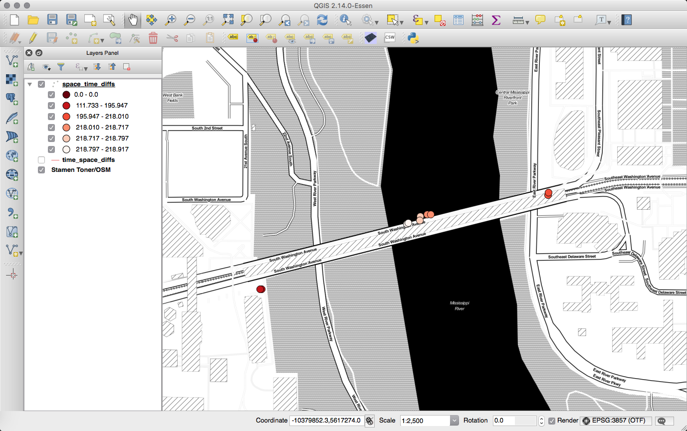
Example 2.2: Space-time diffs
WITH left_join AS (
	SELECT person1.time AS time1, person1.wkb_geometry AS geom1,
		person2.time AS time2, person2.wkb_geometry AS geom2
	FROM person_1_tracks_2 person1
	LEFT JOIN person_2_tracks_2 person2 ON
		ST_Within(person1.wkb_geometry,
		ST_Buffer(person2.wkb_geometry, 5))
),
spatial_overlaps AS (
	SELECT *
	FROM left_join
	WHERE geom2 IS NOT NULL
)
SELECT time1, time2, abs(extract('epoch' from (time1 - time2)) / 60)
AS timediff_in_mins, ST_Collect(geom1, geom2)
INTO space_time_diffs
FROM spatial_overlaps;
Critique #3: Humanities GIS needs better ways to convey and analyze embodied, "felt" space
"I'm very attuned to this in the various classrooms that I find myself in, and I've thought a lot about it. [...] I think we're animals--I mean, I think that's a lot of what it is. It's like: I'm an animal, they're an animal, how are the animals doing?"
- L. Buturian (Literature)
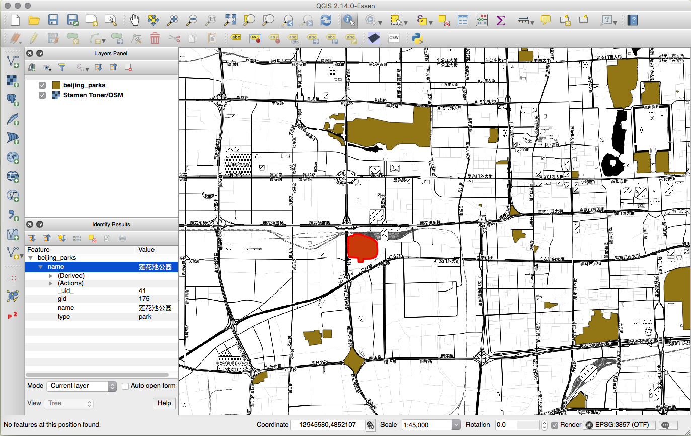
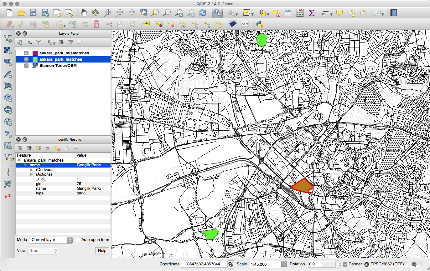
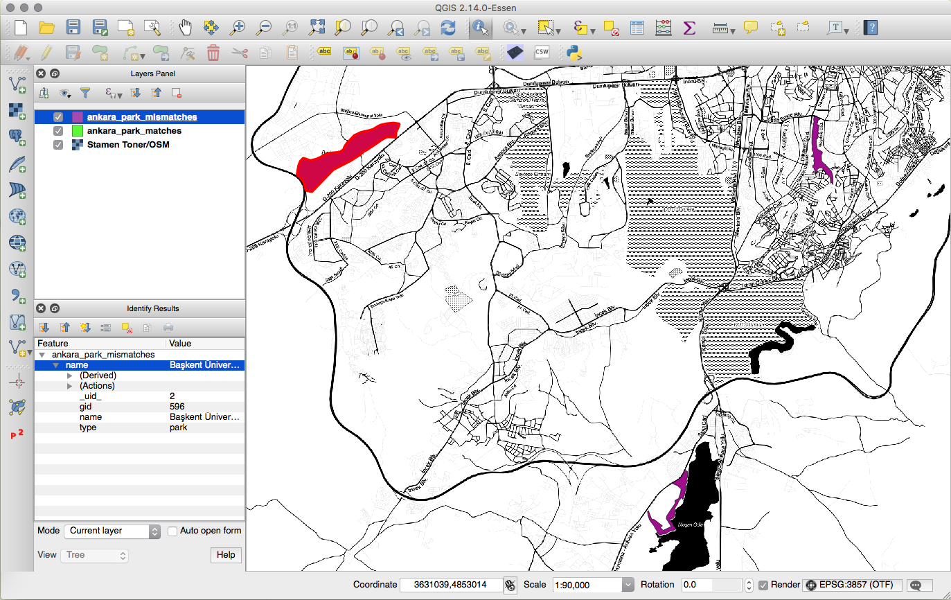
Example 3.1: Hausdorff distance for comparing spaces
WITH target_polygon AS (
	SELECT gid, name, type, the_geom, ST_Centroid(the_geom)
	AS centroid
	FROM beijing_china_osm_landusages
	WHERE gid = 175
),
target_polygon_at_origin AS (
	SELECT *, ST_Translate(the_geom,
	-ST_X(centroid), -ST_Y(centroid)) AS geom_trans
	FROM target_polygon
),
test_polygons AS (
	SELECT gid, name, type, the_geom, ST_Centroid(the_geom)
	AS centroid
	FROM ankara_turkey_osm_landusages
	WHERE type LIKE 'park'
),
test_polygons_at_origin AS (
	SELECT test.gid, test.name, test.type,
		ST_Translate(test.the_geom,
		-ST_X(test.centroid), -ST_Y(test.centroid))
		AS geom_trans
	FROM target_polygon target, test_polygons test
)
SELECT test.gid, test.name, test.type,
	ST_HausdorffDistance(target.geom_trans, test.geom_trans)
	AS hausdorff_distance
FROM target_polygon_at_origin target,
	test_polygons_at_origin test
ORDER BY hausdorff_distance ASC;
Example 3.2: 2.5D visualization with Open Street Map data
CREATE EXTENSION hstore;
CREATE OR REPLACE FUNCTION parse_osm_heights(tags_col character,
	floor_height numeric, default_height numeric)
RETURNS numeric AS $$
	DECLARE
		parsed_tags hstore DEFAULT NULL;
	BEGIN
		parsed_tags := ($1)::hstore;
		IF exist(parsed_tags, 'building:height') THEN
			RETURN (parsed_tags -> 'building:height')::numeric;
		ELSEIF exist(parsed_tags, 'building:levels') THEN
			RETURN (parsed_tags -> 'building:levels')::numeric * $2;
		ELSE
			RETURN $3;
		END IF;
	EXCEPTION
		WHEN plpgsql_error THEN RETURN $3;
		WHEN invalid_text_representation THEN RETURN $3;
		WHEN others THEN
			RAISE NOTICE 'not a valid hstore';
			RETURN $3;
	END;
$$ LANGUAGE plpgsql;
Questions
"Questions drive humanities scholarship, not hypotheses..."
- Bodenhamer, D. J. (2010). The Spatial Humanities: GIS and the Future of Humanities Scholarship
References: Work of Interest from Interviewees
- Immigration History Research Center. University of Minnesota.
- Kilde, J. H. (2015, 5 January). "Houses of Worship in the Twin Cities: Using Spatial Mapping to Gauge Interaction among Immigrant Religious Groups, 1849-1924". Paper presented at the American Society for Church History, New York City, NY.
- Houses of Worship. University of Minnesota.
- Buturian, L. (2015). The Changing Story: Digital Stories that Participate in Transforming Teaching & Learning. Retrieved from: http://www.cehd.umn.edu/the-changing-story/
References
- Rhetorica ad Herennium. (Harry Caplan, Trans., 1954). Loeb Classical Library. Retrieved from: http://www.laits.utexas.edu/memoria/Ad_Herennium_Passages.html
- Wilson, M. (2009). "Towards a Genealogy of Qualitative GIS". Qualitative GIS. London: SAGE Publications Ltd.
- Hägerstrand, T. (1970). "What About People in Regional Science?". Papers of the Regional Science Association, Vol. XXIV.
- Corti, et al. (2014). PostGIS Cookbook. Birmingham, UK: Packt Publishing.
- Bodenhamer, D. J., Corrigan, J. & Harris T. M. (Eds.). (2010). The Spatial Humanities: GIS and the Future of Humanities Scholarship. Bloomington, IN: Indiana University Press.
References: Data & Maps
- "City Maps" (2016). City of Lawrence, Kansas. Retrieved from: https://www.lawrenceks.org/city_maps#gis-data
- U.S. Census Bureau. American Community Survey, 2014 American Community Survey 5-Year Estimates, Table S0101, S1902, B05012. Using American FactFinder.
- Map tiles by Stamen Design, under CC BY 3.0. Data by OpenStreetMap, under ODbL.
- "Metro Extracts". Mapzen. Retrieved from: https://mapzen.com/data/metro-extracts/
References: Software
- PostgreSQL (Version 9.5.2). [Computer software]. Retrieved from: https://www.postgresql.org
- PostGIS (Version 2.2.2). [Computer software]. Retrieved from: http://postgis.net
- QGIS (Version 2.14.0-Essen). [Computer software]. Retrieved from: http://qgis.org/en/site/
- FitnessKeeper, Inc. (2016). Runkeeper - GPS Track Run Walk for Android (Version 7.1.0). [Mobile application software]. Retrieved from: https://play.google.com/store/apps/details?id=com.fitnesskeeper.runkeeper.pro
- ST_ClusterDBSCAN. (2016). "8.9 Spatial Relationships and Measurements". PostGIS Documentation. Retrieved from: http://postgis.net/docs/manual-dev/ST_ClusterDBSCAN.html
- ST_HausdorffDistance. (2016). "8.9 Spatial Relationships and Measurements". PostGIS Documentation. Retrieved from: http://postgis.net/docs/ST_HausdorffDistance.html
- Akagi, M. (2016). Qgis2threejs plugin (Version 1.4.2). [Computer software]. Retrieved from: https://plugins.qgis.org/plugins/Qgis2threejs/